Coulter Motte
Coulter Motte Details
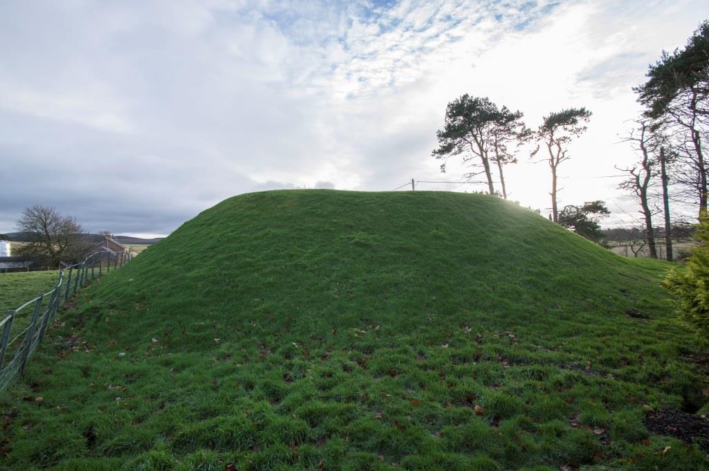
Coulter Motte, mound only survives of C13 castle of the Coulters probably abandoned C14 when estate split in two
- Closest To: Coulter, Bigga
- Access: S.O.A.C. Public Access
- Grid Reference: NT019363
Coulter Motte is a small oval mound enclosed within a rectangular fence just east of the road through Wolfclyde. It is open to the public, but there is no viewing area, and interpretation of the site on the board here is minimal.
The castle is supposed to have originally had a small bailey associated with it, but this is now occupied by housing and private gardens and may not be seen; any trace of a possible ditch around the motte has similarly long since vanished. The summit area is perhaps 12-15 metres across, enough for a modest hall or tower, but there is no trace of anything here to see.
The castle was probably occupied by Alexander de Cutir, a witness of the earl of Lennox in documents of the mid 13th century, a surname indicating that Alexander or his predecessors were part of the generation of Flemings settled in Clydesdale during the latter 12th century. The castle was probably destroyed during the wars of independence, with the main residence being a hall of sorts in the bailey, but by 1360 the estate had been partitioned, and it is unlikely that the subsequent lords maintained any place of high status here afterwards.
The ruins of Coull Castle can be seen from the B9094 in rural Aberdeenshire, and are reached via an unkept footpath from Coull church. The ruins are of an impressive 13th century castle consisting of a single courtyard within a ditch overlooking the Tarland Burn, built by the Durward family and destroyed during the Wars of Independence.
The Durwards originally held the surname de Lundie and came from Fife. Malcolm de Lundie married one of the daughters of the Earl of Mar, was doorward for King William the Lion, and took the prestigious position as his name. His son Thomas married one of the daughters of the Earl of Atholl and claimed the earldom of Mar in right of his mother. King Alexander II believed that Mar should be broken up, and in 1228 granted Durward a substantial part of the Earldom, which was renamed the Barony of O’Neill, but gave the title of earl to his rival Duncan. By 1233, Thomas was dead and his son Alan was his successor. Either Thomas or Alan built the castle at Coull as the principal seat of the Barony. Alan was a principal rival of the Comyn family during the minority of Alexander III, but overreached himself and was driven into exile from 1251 to 1255 before returning and seizing power again for two years. Eventually a deal was struck between the two factions, and Alan was able to enjoy his estates until perhaps about 1270, when he died. The barony of O’Neill reverted to the Crown and was granted to the Earl of Fife, and after his assassination in 1288, it continued to be held by his daughter Isabella.
In 1299, Isabella granted Coull to John de Hastings of Abergavenny under the aegis of Edward I of England, but sometime between 1302 and 1305 it had passed to David de Strathbogie, Earl of Atholl and opponent of Robert Bruce, because in that year he was ordered to hand the lands of Coull back to the Countess. The castle is not mentioned and had probably been seriously damaged by Andrew Murray in 1296-98; the main tower was certainly undermined and needed repairing. It seems probable that John Hastings attempted this, but the assault by Bruce on the lands of de Strathbogie in 1308 would have targeted the repaired castle, and it was probably destroyed at this time.
The castle when complete occupied a site at the top of a river-cliff and was defended on two sides by a deep ditch, which was probably the quarry for the castle masonry. A hall range overlooked the river cliff to the south-west, which probably terminated in a large round tower at the southern end. To the north-east of this was the large round tower-keep, built partially upon a steep slope which provided a wide terrace overlooking the ditch to the north-east. Upon this terrace, the curtain wall turned north-west and followed the terrace to meet the main gatehouse in the northern corner. Between the tower-keep and the SE tower was a sally port. At the northern end of the hall block, the curtain wall carried on to terminate in a third round tower, from which the curtain wall climbed the steep slope north-eastwards to terminate at the main gatehouse. This gatehouse was made of two elongated D-shaped towers, and had a drawbridge with a deep pit between the two towers.
Most of the castle survives as footings, although some parts of the wall have disappeared completely, and parts of the hall block and tower-keep survive to a far greater extent. The whole site is sometimes used for livestock grazing, with inevitable decay of the structure as a result. Clearly access is not possible when this is the case.
Become a supporter of my work to access a more detailed history